Category Archives: Southeast Asia

Bangkok’s Historic Temples

FacebookTwitterGoogle+Share

As the historical term Indochina implies, Mainland Southeast Asia was a crucible of cultural influences originating from both India and China.   As early as the 1st century CE,  an ancient kingdom known as Funan controlled the trade routes of southern Indochina.   By the 6th century Funan had split into two successor states: the Cambodian Khmers in the south and the Mon-Dvaravati in the northern region that would eventually become Thailand.

MAP SE ASIA 2

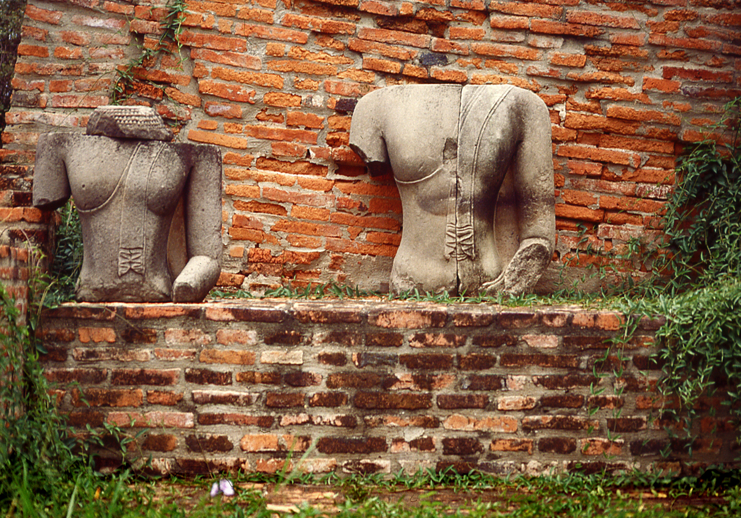
These ancestors of the Thai came to rule a large area of north-western Indochina situated between the Burmese and Khmer empires.  Over the centuries, numerous wars were waged by these three rival states, whose  territorial  boundaries fluctuated as each one gained temporary ascendancy.  Monuments were built, perio-dically destroyed by warfare, and rebuilt, resulting in the inter-mingling  of  regional  styles  that  characterizes  Thai  architecture.

1 Buddhas Ayutthaya
Remains of Past Glories at Ayutthaya

By the 12th century,  the Thai people had established the kingdoms of Sukhotai in the south and Chiang Mai in the north and had developed a  distinctive  national  culture,  including  the  adoption of Theravada  Buddhism  spread  by  missionaries  from  Sri  Lanka.


Theravada is one of three branches or schools of Buddhism which claims to be the oldest and most  authentic,  transmitted  from  India  to  Sri Lanka in the 3rd century BCE.  Theravada Buddhism is practiced throughout Southeast Asia;  in contrast,  Mahayana sects predominate in East Asia and the Tibetan-Himalayan region follows the Vajrayana tradition. 

1 BuddhaFile
Buddha Images are Often Clothed in the Saffron Color Worn by Thai Monks

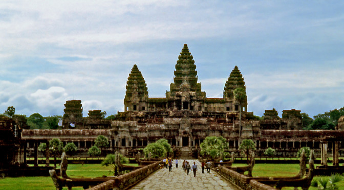
In  the 14th century a third powerful Thai kingdom arose in the Chao Phraya River basin.  For 400 years the empire of Ayutthaya was the leading political and cultural force in the region, absorbing the neighboring kingdom of Sukhotai, defeating the Khmers of Angkor and extending its conquests as far as Burma.   Ayutthaya was eventually destroyed in the Burmese Wars of the late 18th century and the Thai capital was moved south to the site of present-day Bangkok.

BK Ayuthaya panorama SMALL
View of Ayutthaya from the River (Wat Chaiwatthanaram)

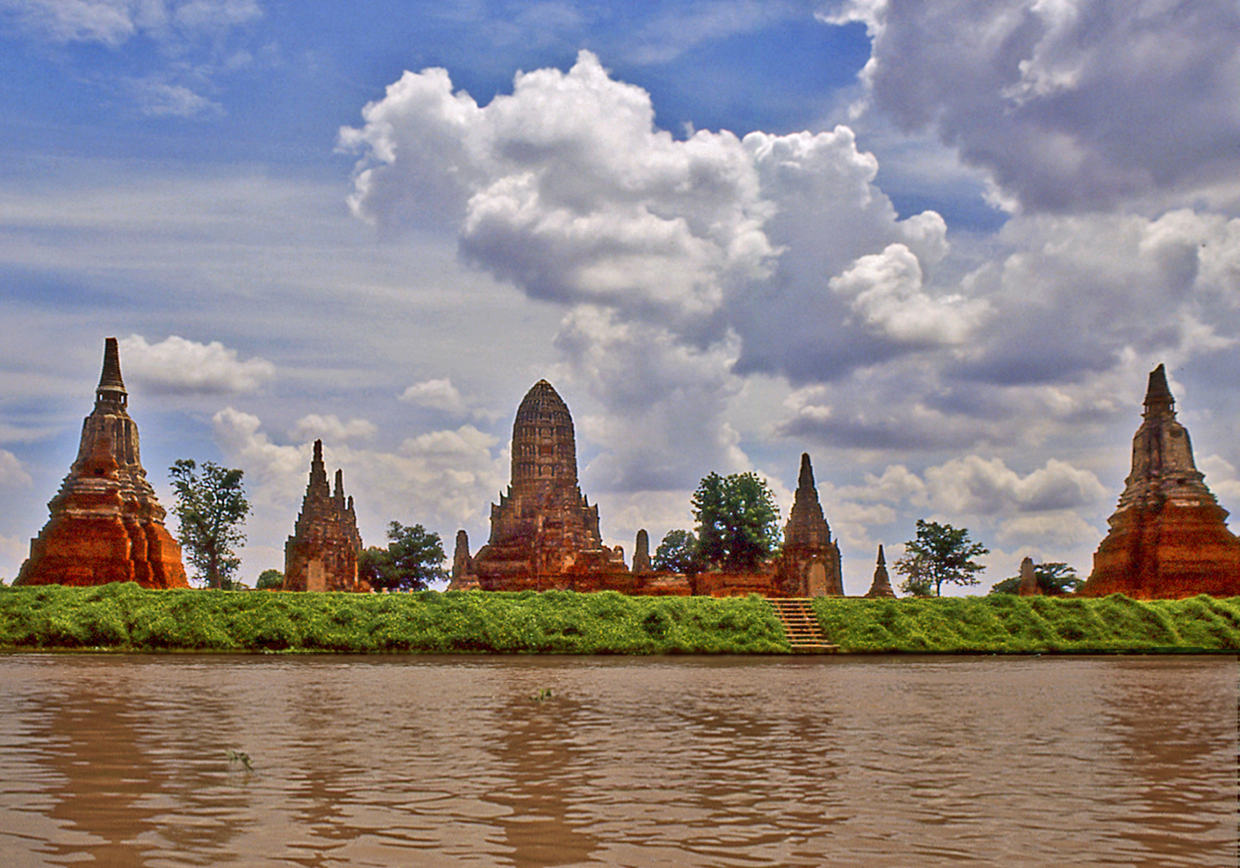
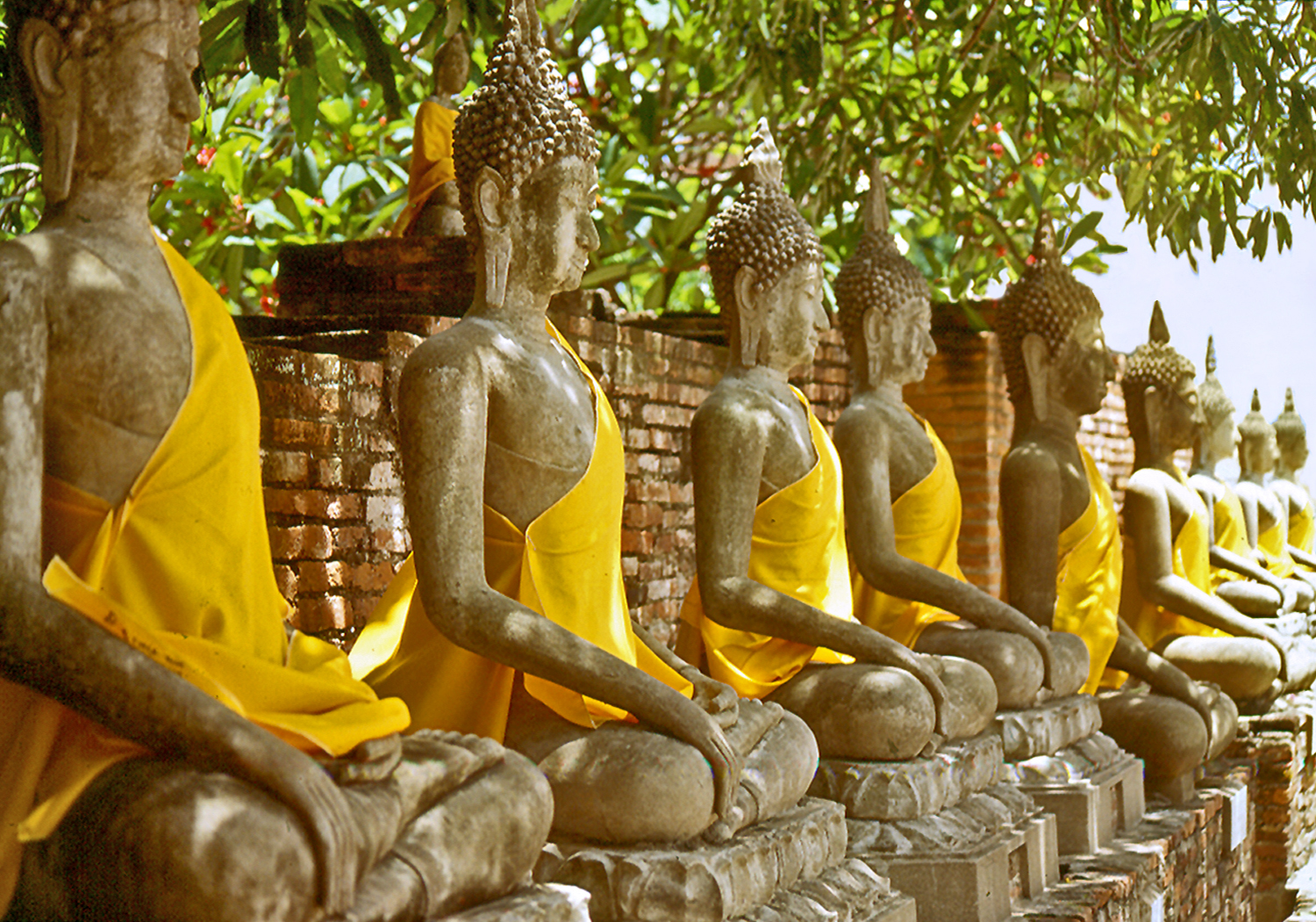
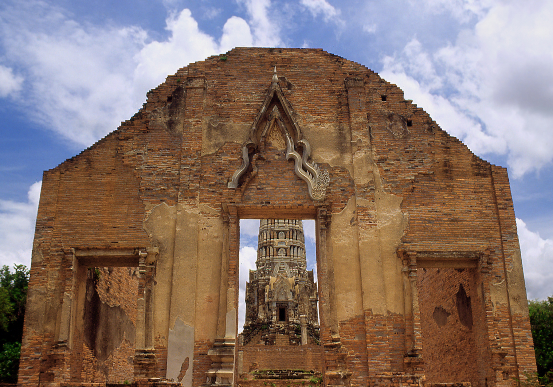
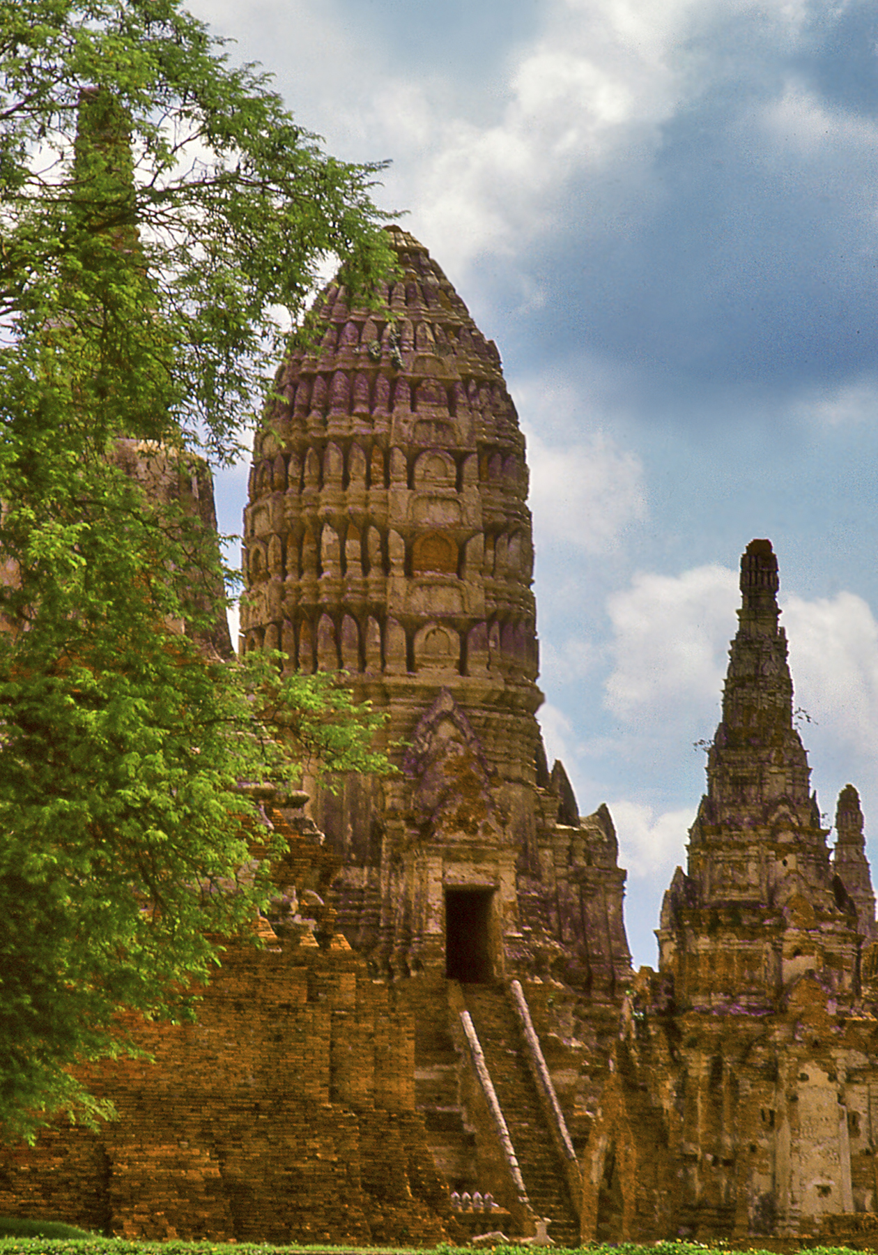
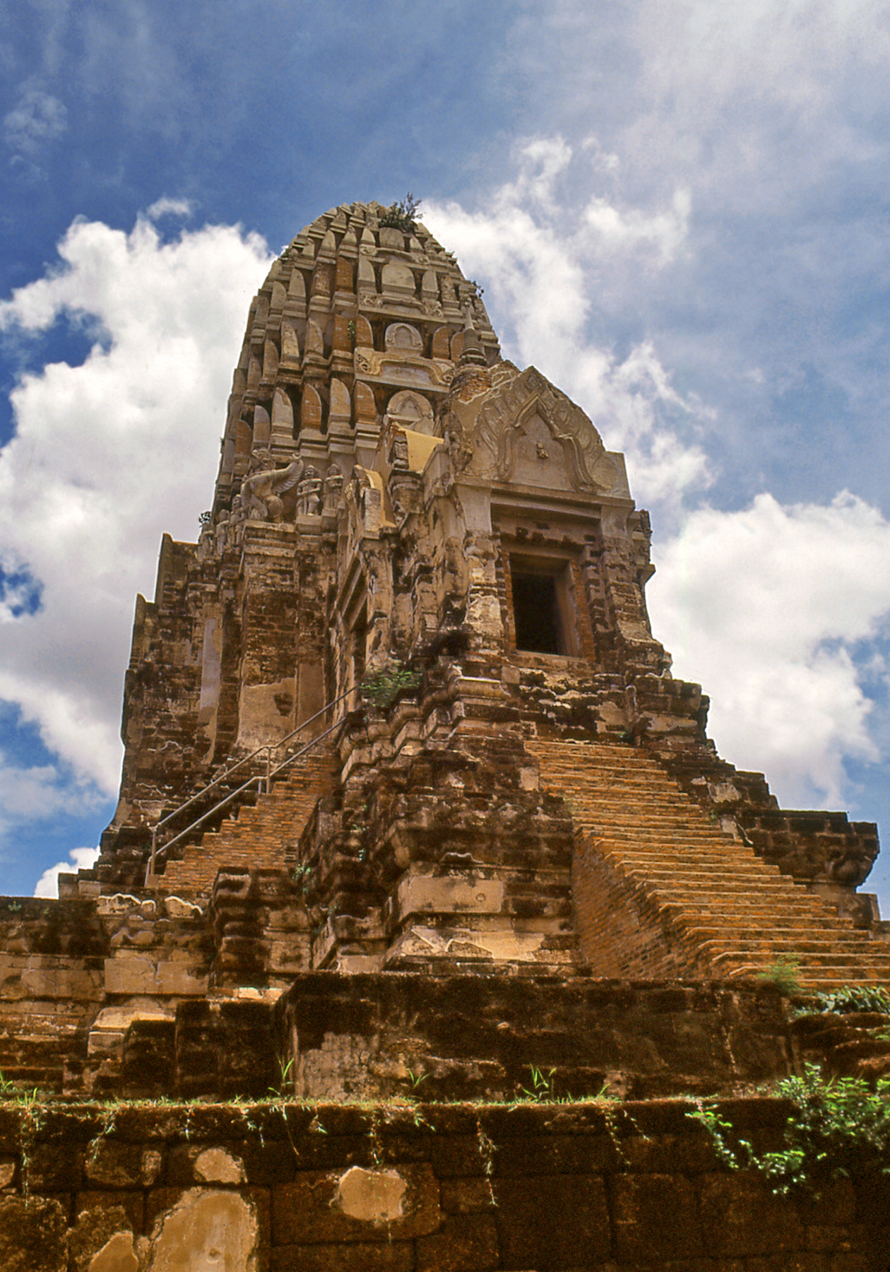
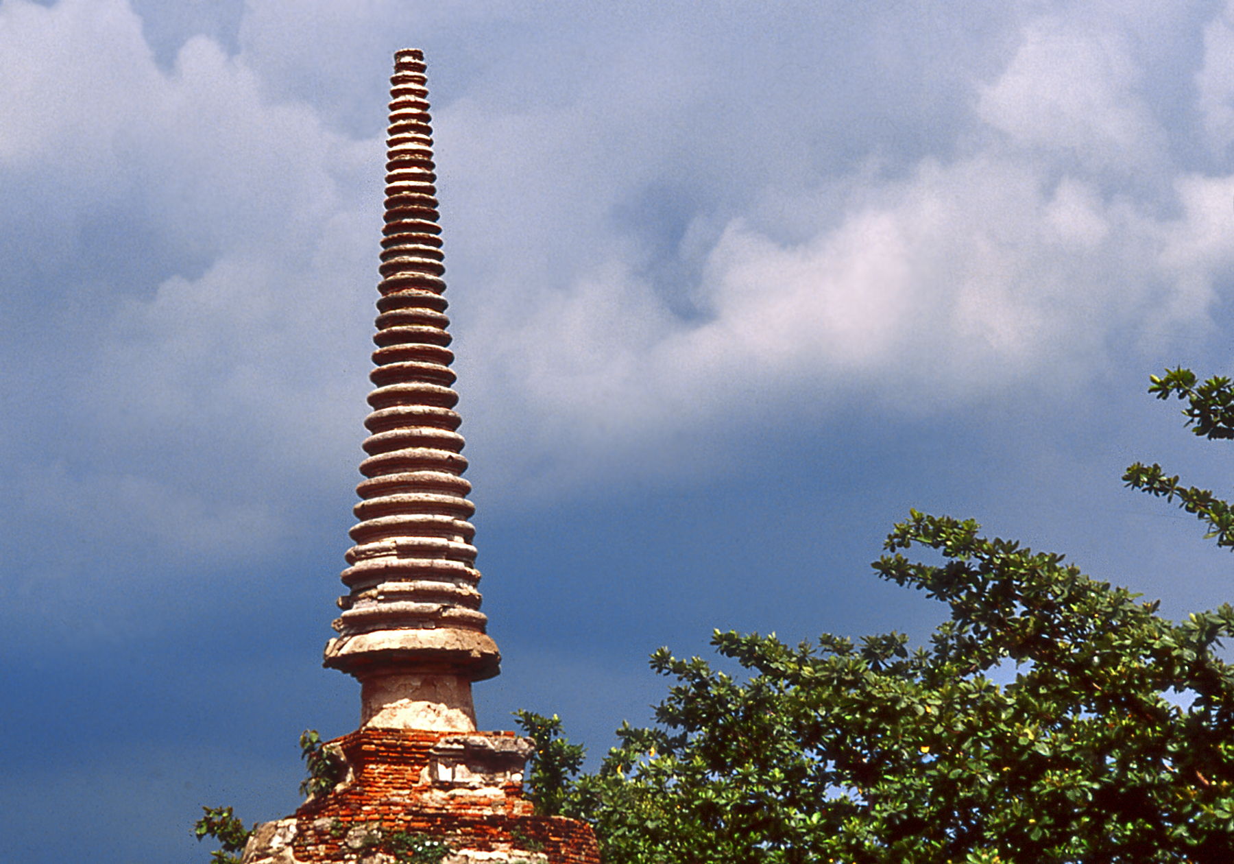
The ruins of Ayutthaya lie some 80 km. north of Bangkok along the banks of the Chao Phraya, and a journey by boat offers fascina-ting views of daily life along the river.   Approaching  Ayutthaya,  an impressive panorama suddenly unfolds as the tall spires of the old capital come into view.  The monuments display the syncretism of Thai architecture that incorporates influences from the Khmers (corncob shaped prang towers),  the Shan (elongated spires) and the Burmese (bell-shaped stupa domes).  As a result of this cultural  mix, Thailand  displays  the  greatest variety of  Buddhist stupa  styles  of any  country  in  Asia

BK Ayuthaya Monastery
Former Monastic Hall at Ayutthaya

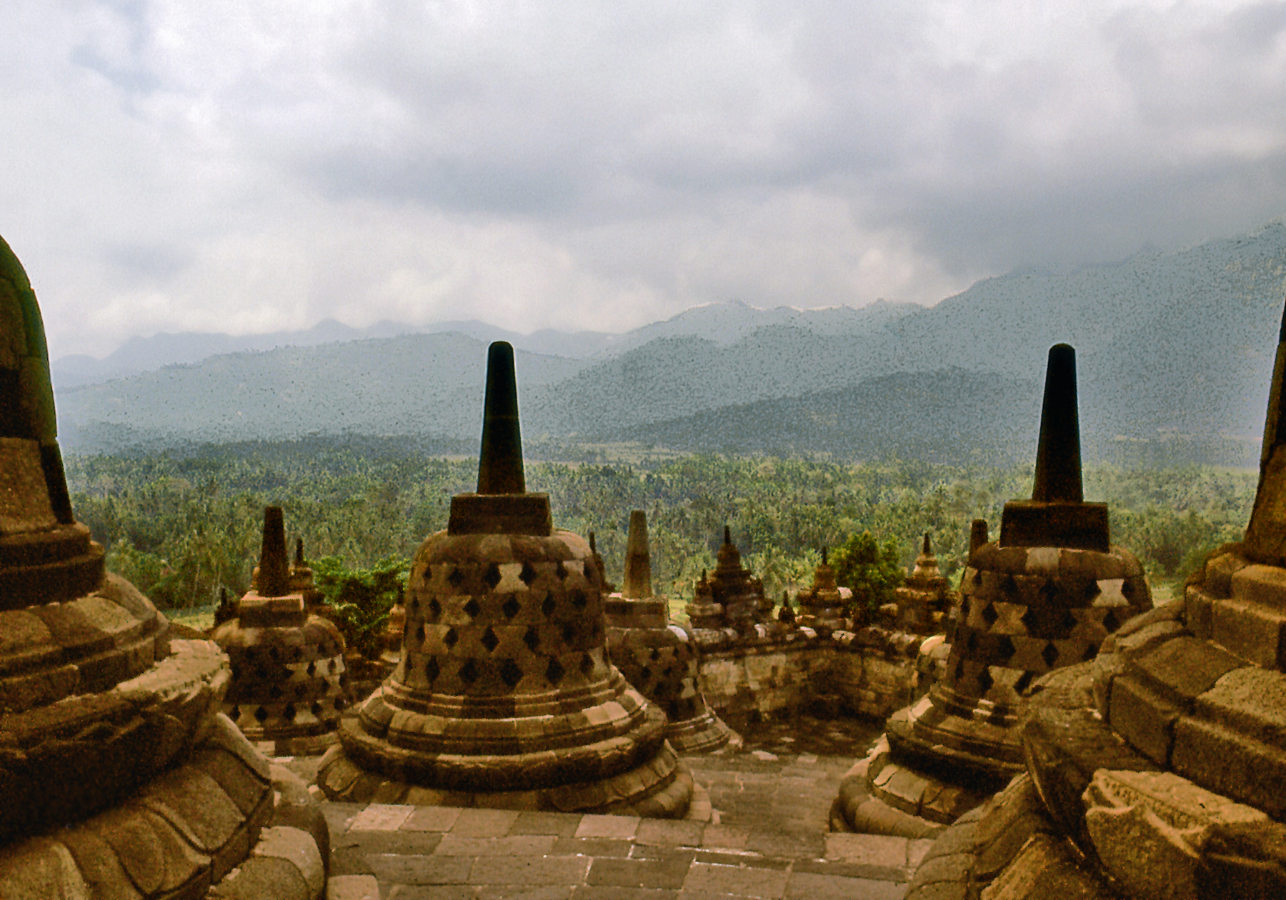
Stupas (called chedi in Thai) originated in India, where the rounded shape of ancient funerary mounds was adopted for Buddhist reli-quary monuments.   These mounds were often set atop platforms and topped by elaborate umbrellas.   Over time each component part of the stupa was given a symbolic meaning and evolved distinctive regional  variations  as  Buddhism  spread  across  Asia.

1 Ayutthaya temples
Temples of Ayutthaya

Wat is the Thai word for temple. Wat Ratchaburana was built in the mid 15th century by the seventh king of Ayutthaya.   It features a tall Khmer-style prang tower over the sanctuary, which is covered with stucco decoration, and three porticoes facing east, north and south, set atop a high platform accessed by steep stairs. The silhouette is reminiscent of the medieval Hindu temples of north-central   India.

Ayuthaya indian
View of Wat Ratchaburana

The Thai rulers of Ayutthaya  may  have  also  adopted aspects of  the royal funerary cult of the Khmers of Angkor and began to erect commemorative  stupas  to  serve  as  their tombs.

BK Ayuthaya Chedis
Wat Phra Si Sanphet

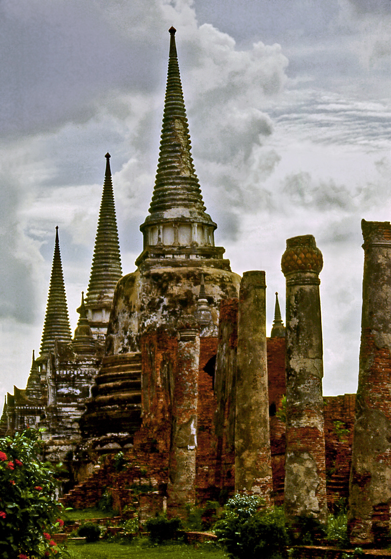
Wat Phra Si Sanphet,  built in 1448, is a large temple complex located within the ancient royal palace precinct.  Its three graceful bell shaped stupas were built as memorials to encase the ashes of former kings. They typify the Ayutthaya style, where elongated spires of superimposed  rings take up almost half the height of the monument.  They correspond to the ceremonial umbrellas that top Indian and Sinhalese stupas.

Ayuthaya Spire
Ayutthaya Stupa Spire

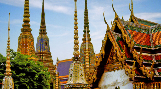
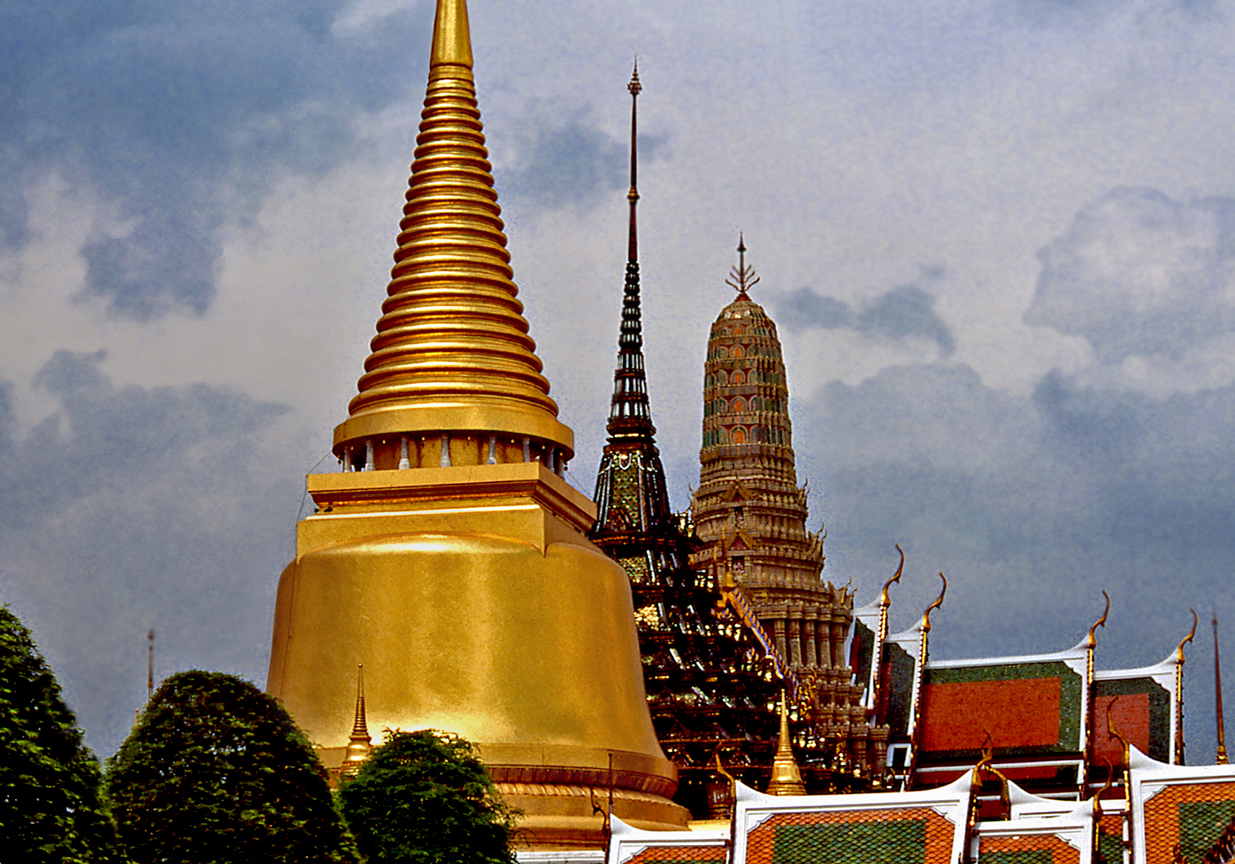
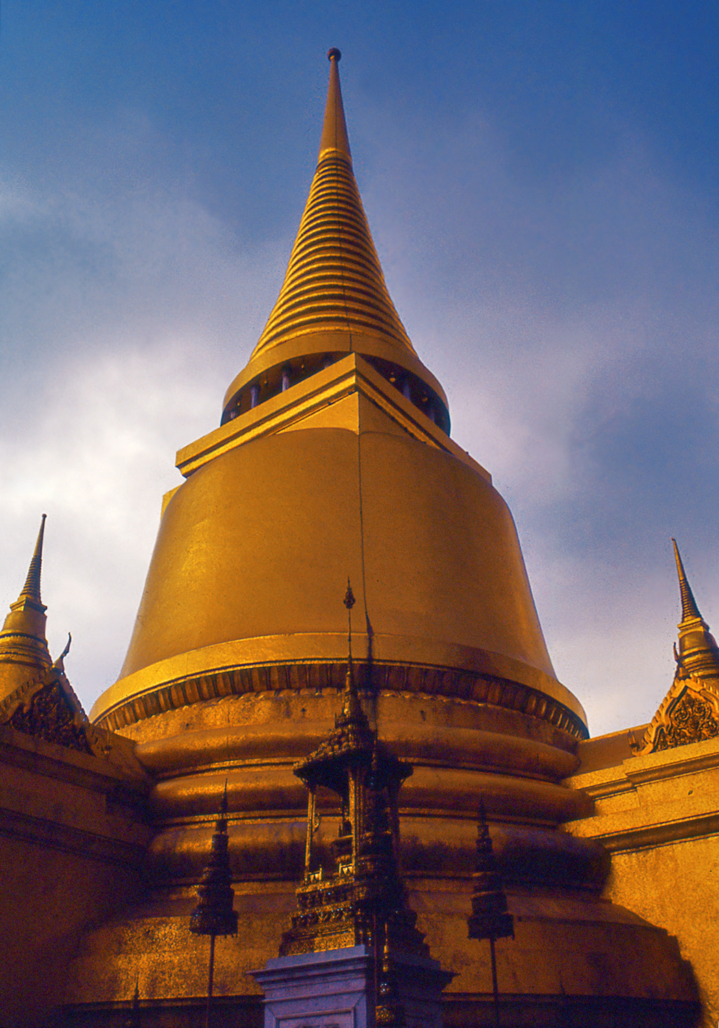
Thailand’s ruling Chakri dynasty traces its lineage to the founding of Bangkok in 1782.  Wat Phra Kaew (also called the Temple of the Emerald  Buddha)  was  built  inside  the  royal  palace  compound  by King Rama I to enshrine a precious image of the Buddha which is considered the protector of the country. The temple complex contains  many  exquisitely  ornamented  buildings,   including  three adjacent  structures,  each one  built in a  markedly  different style: Phra Siratana Chedi, a golden Sinhalese bell-shaped stupa housing Buddhist relics,  the Royal Pantheon featuring a Khmer-style prang tower and, between them, the Thai-style Phra Mondop, a library containing sacred Buddhist texts.

BK Royal Palace Styles
Distinctive Architectural Styles
1 Golden
Golden Chedi

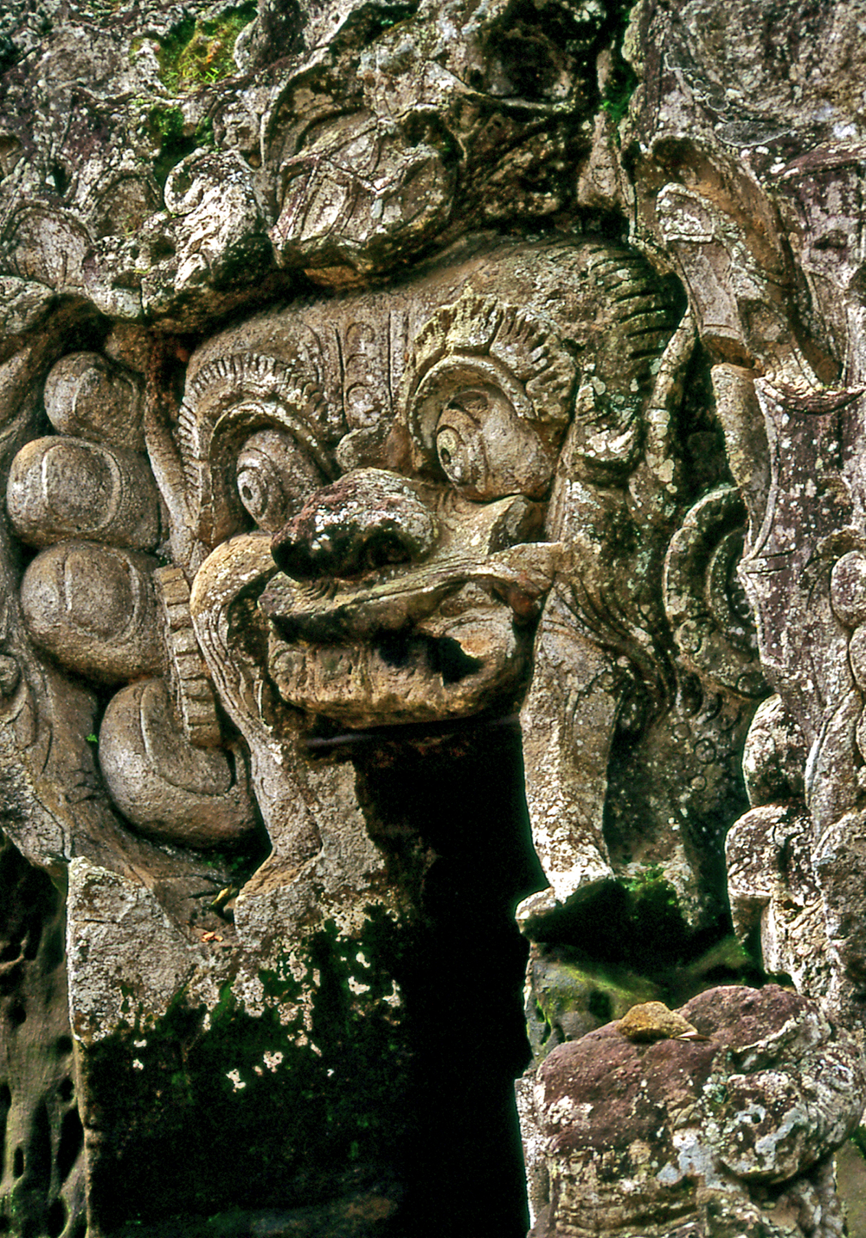
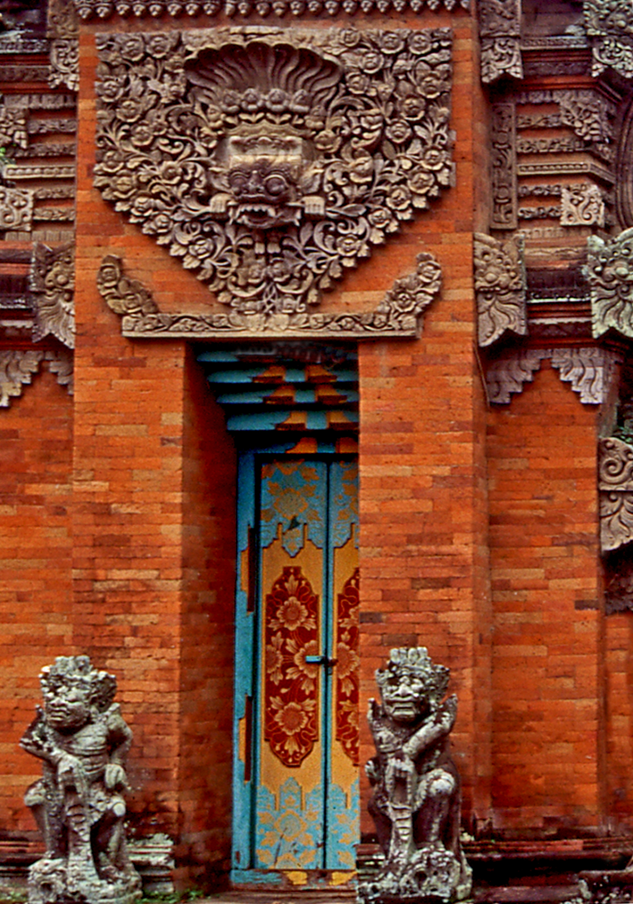
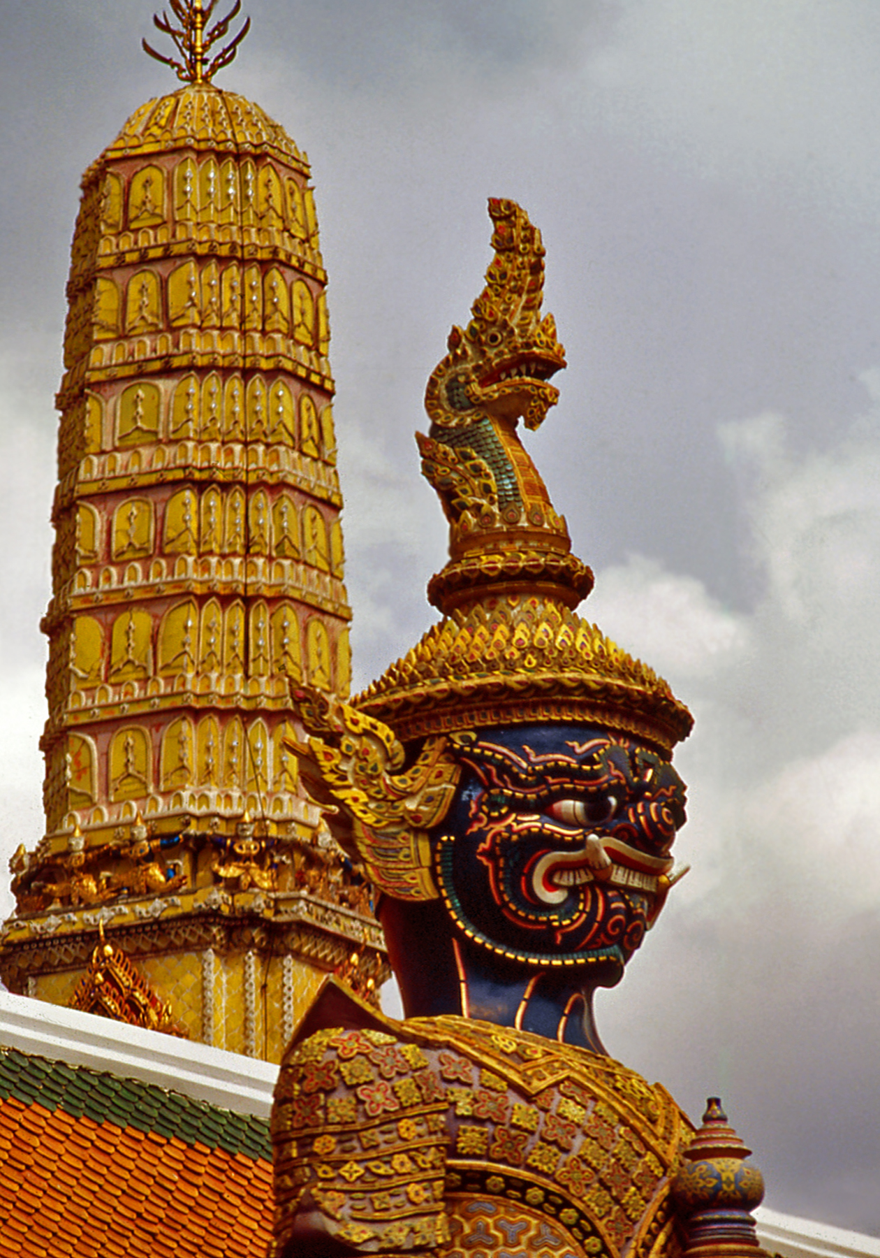
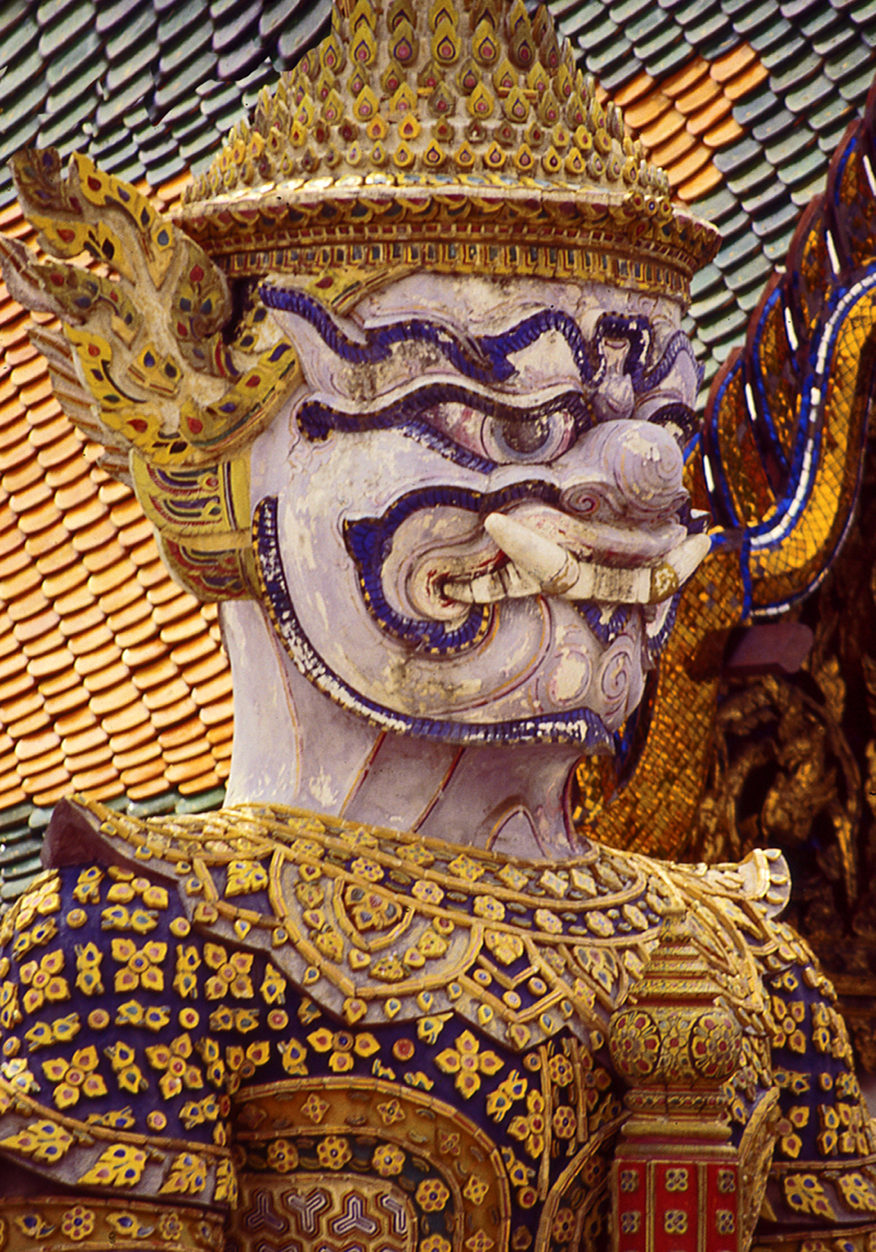
The temple complex is enclosed by a wall with a covered gallery painted with scenes of the Ramakien, Thailand’s national epic, de- rived from the Indian Ramayana.   Entrances are protected by fero-cious guardian figures in battle attire similar to the masks, head-dresses and elaborate costumes of classical Thai dance drama. Temple guardian images are found throughout Asia,  and depict the demonic spirits of ancient nature  cults  tamed  and  converted  into defenders  of  Buddhism.

BK Guardian Spire
Fierce Guardian Figure
1 Guardian
Detail of a Guardian

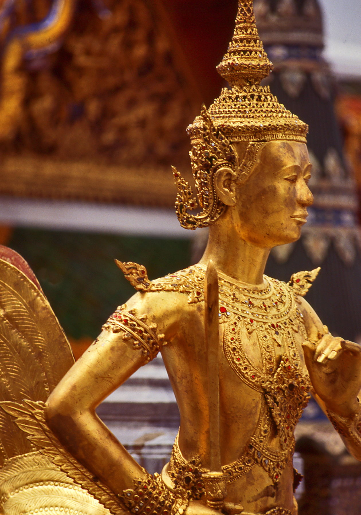
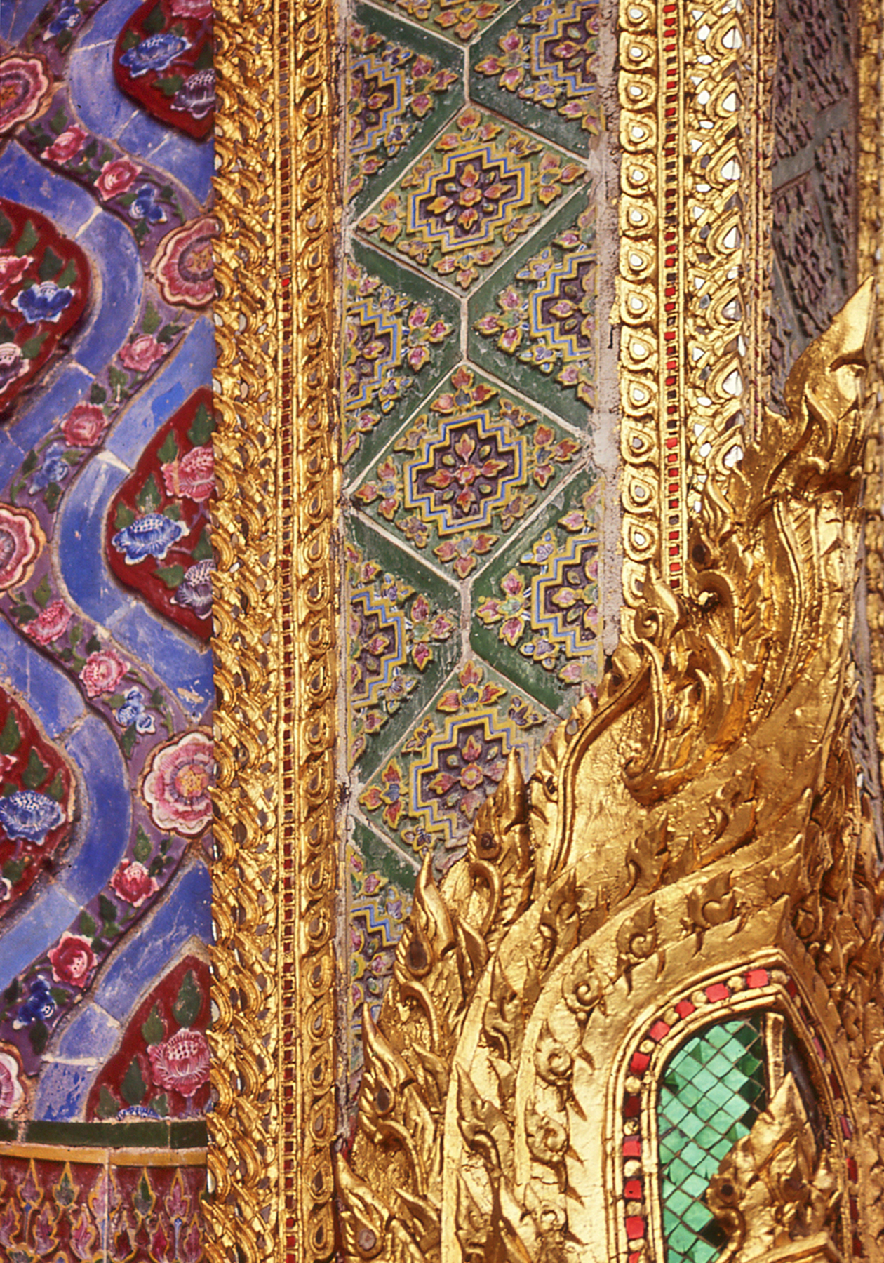
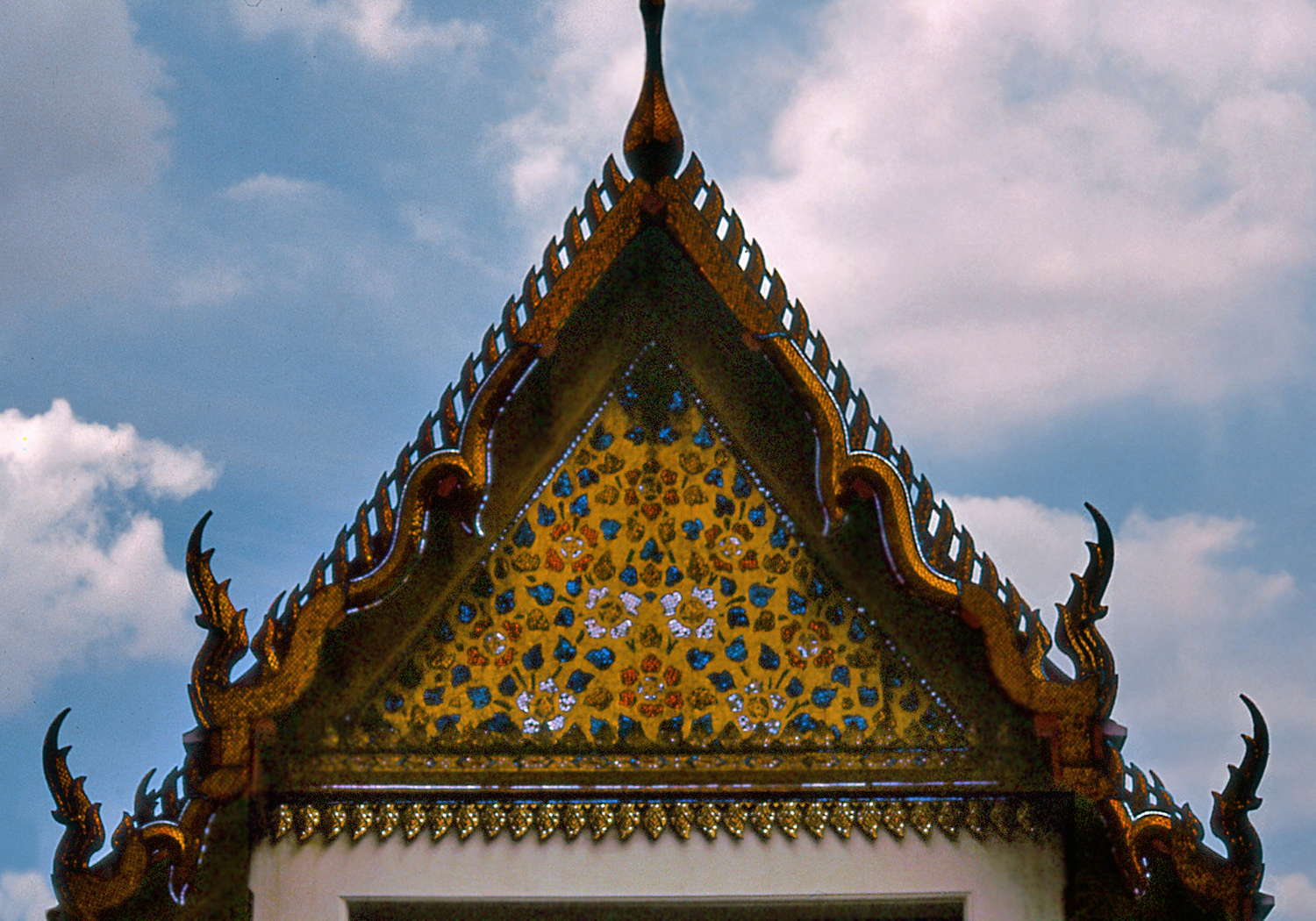
                              Under the Chakri dynasty the Thai kingdom (known in the West as Siam) prospered, avoiding colonization by the European powers and laying the foundations of a modern nation state.   During this period, in the late 18th and early 19th centuries,  older architectural models were reinterpreted with the addition of elaborate surface decoration in glittering  gold  leaf  and mosaics of shell,  ceramic and colored glass.

BK Angel
Graceful  Dance Pose
1 Mosaics
Elaborate Decoration

The characteristic Thai roof profile also emerged at this time, featuring sloping tiled surfaces with high gables and overhanging eaves enhanced by long pointed finials marking the ends of the ridge poles.  The exaggerated effect is reminiscent of southern Chinese architecture  which  may  have  inspired  it.

ROOF
Overlapping Roof Eaves
Library VERT
Glittering Surfaces


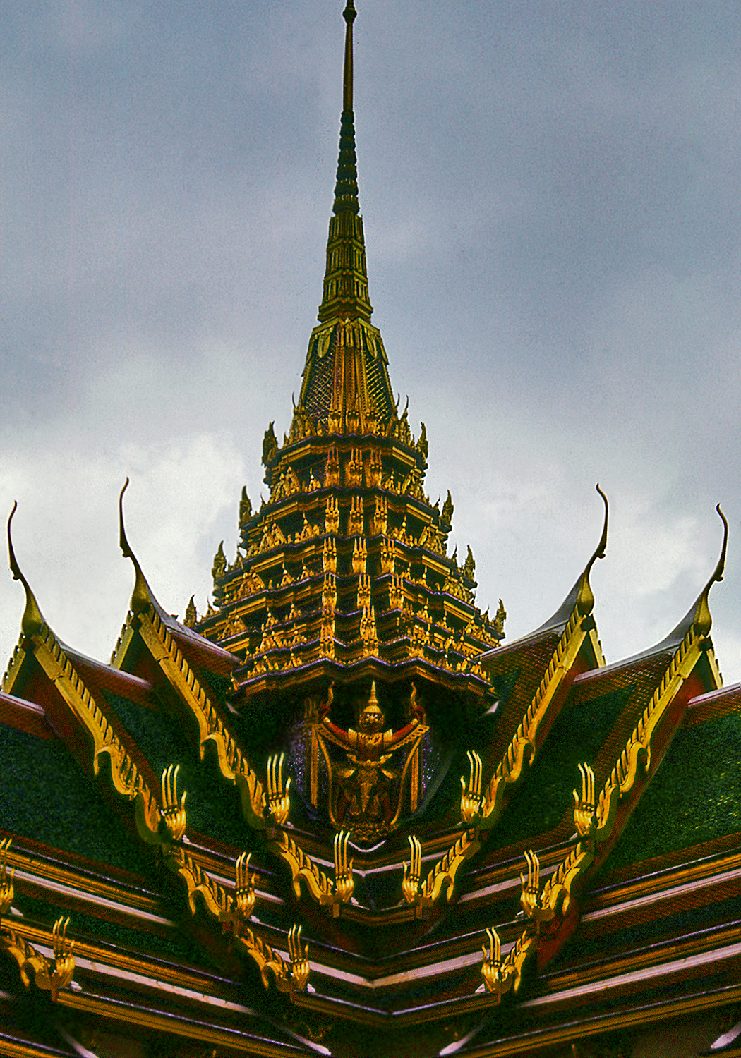
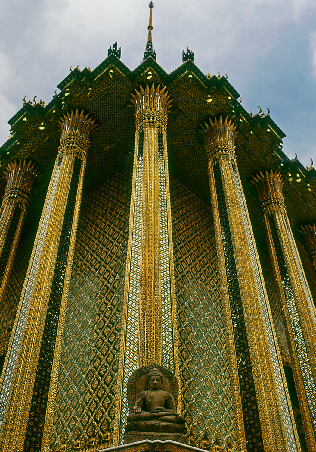
Phra Mondop, the sumptuous library building within the Grand Palace’s  Wat  Phra  Kaew  temple  complex,  was  built by king Rama I in the late 18th century.  It epitomizes the Thai style, with its super-imposed roof structures and overlapping eaves, dramatic upturned finials  and  richly  decorated  surfaces.

1 ROOFLINE REV
Typical Thai Roof Profile

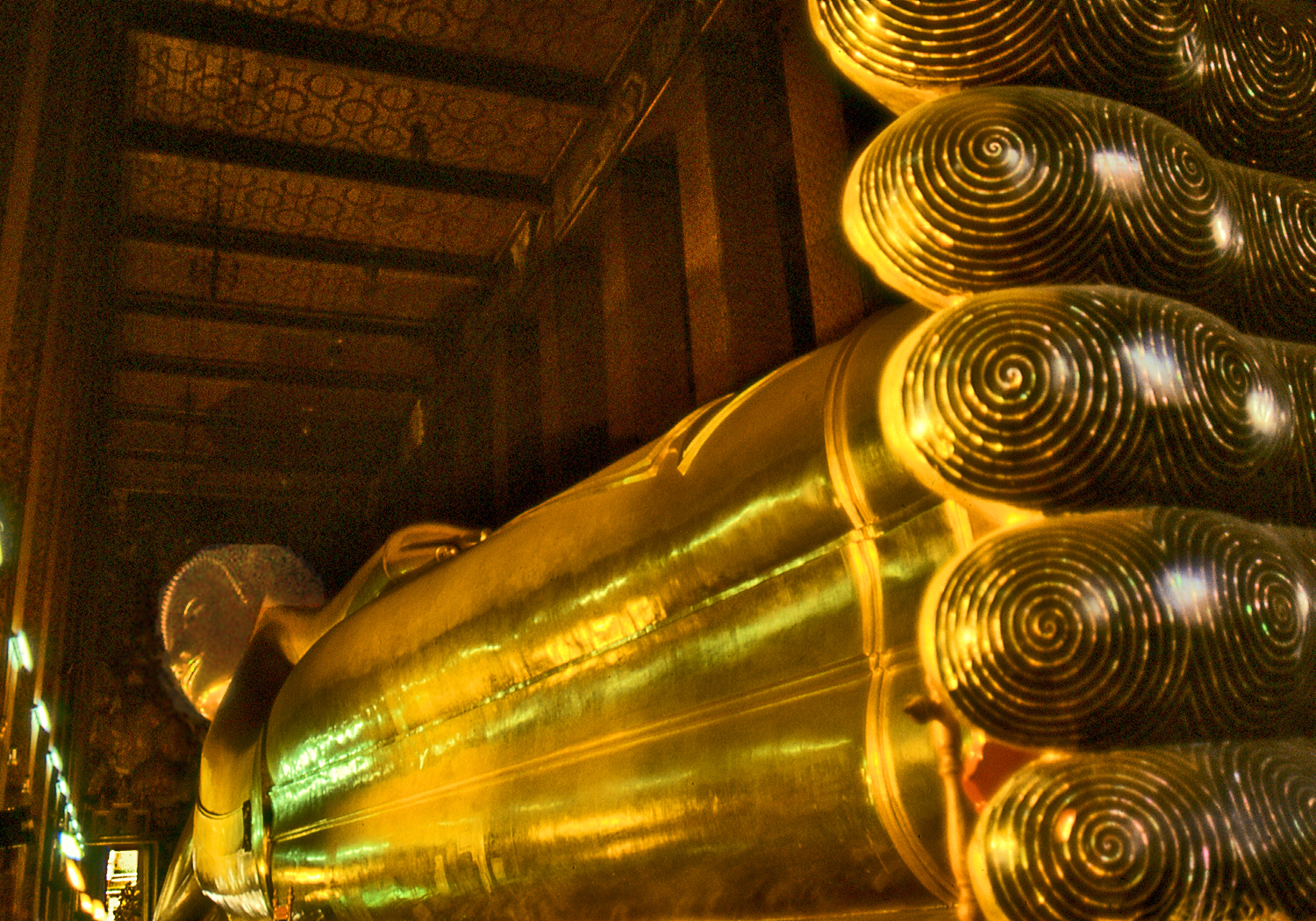
Wat  Pho  is  one  of the oldest and largest wats in Bangkok and contains many historic Buddha images, including a huge gilded reclining Buddha. The 46 m. long statue depicts Buddha’s entry into  Nirvana  at  the  end of his earthly incarnations.   The soles of his feet show auspicious symbols and chakras,  or energy points.   Interestingly,  Wat Pho is  a center for the study of traditional medicine and Thai massage which, like acupuncture, focuses on  pressure  points  affecting  the  flow  of energy  in  the  body. 


BK Bangkok Chinese Spires SKY
Chedis of Wat Pho

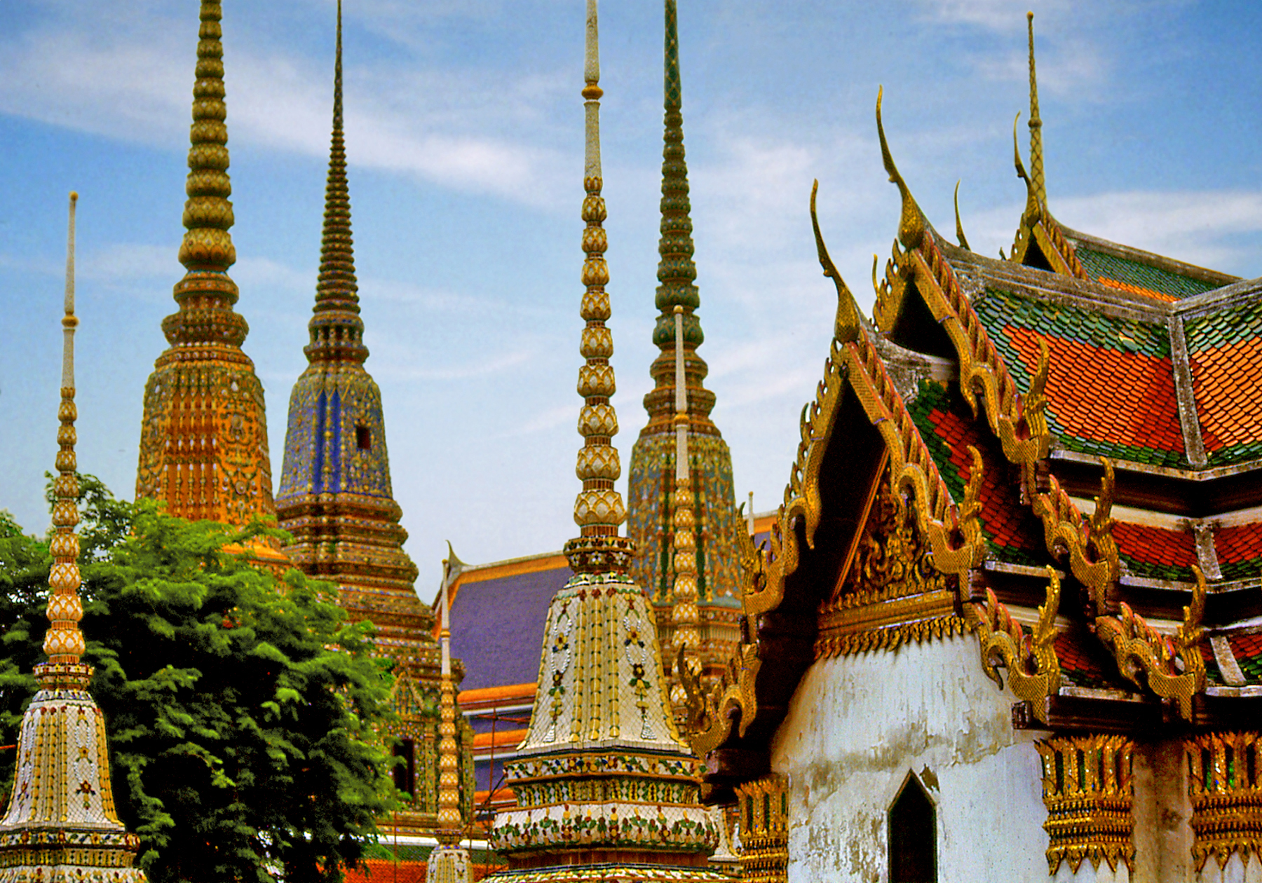
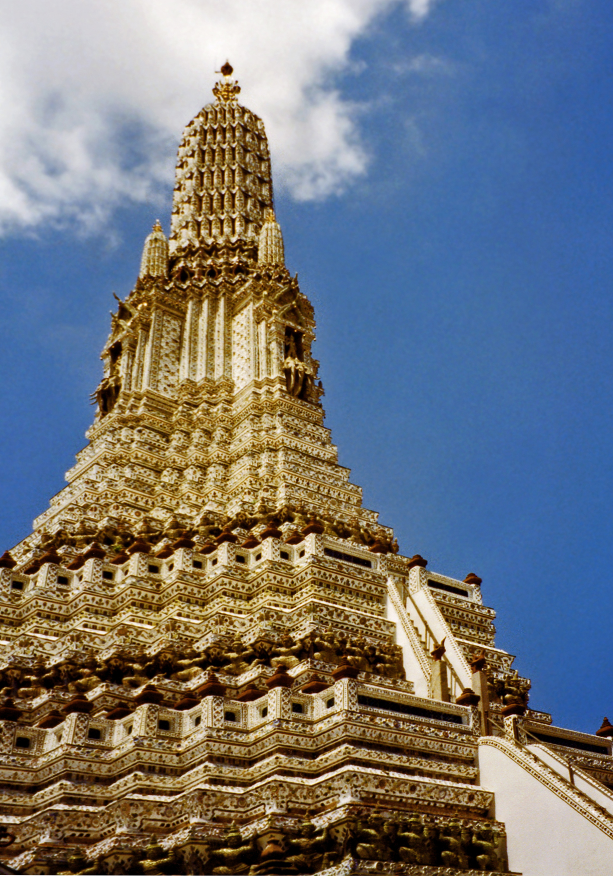
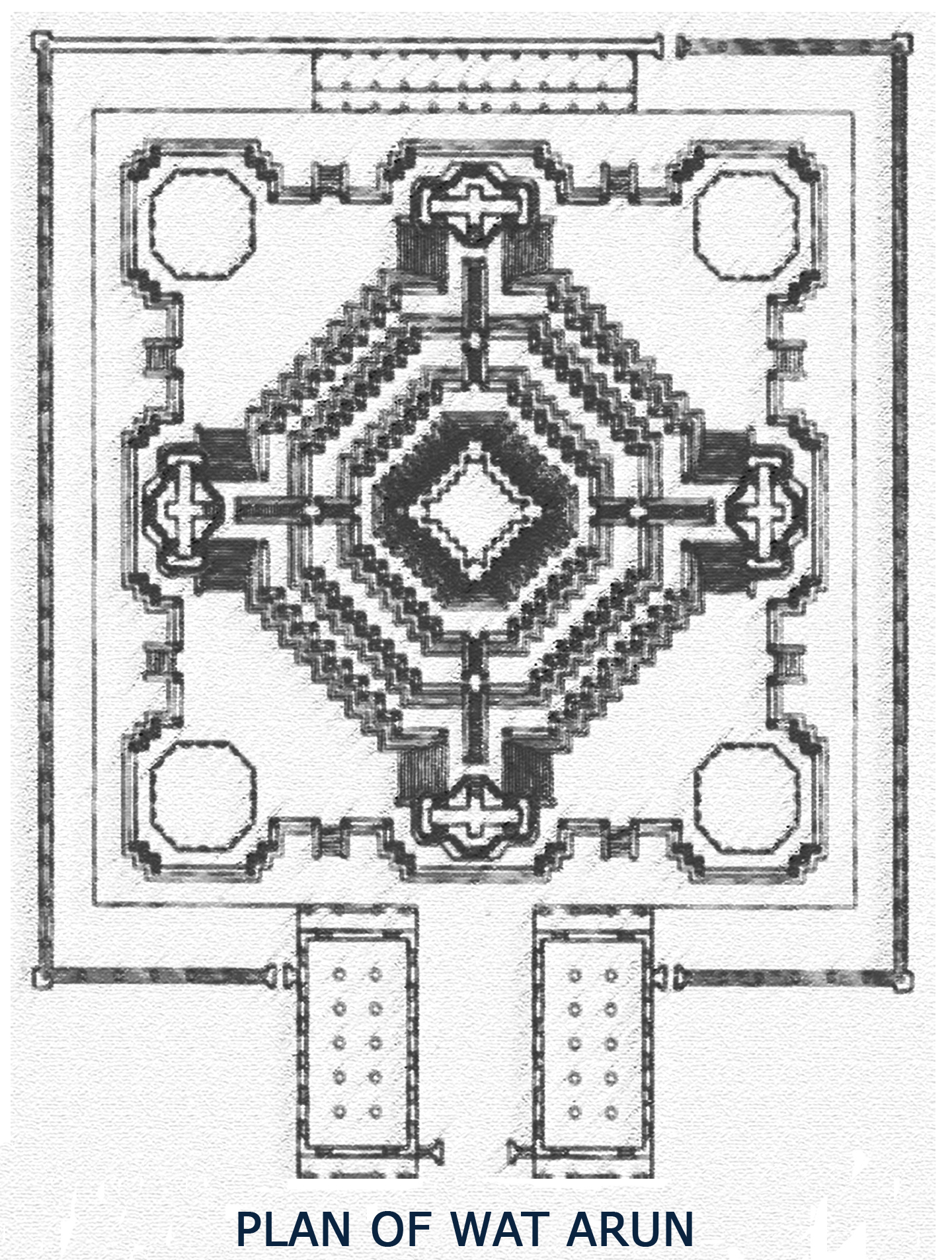
Chinese influence is more explicit in the use of porcelain mosaics to decorate the surface of chedis at Wat Pho and at Wat Arun, the famous “Temple of the Dawn.”  Construction of this magnificent structure was begun by king Rama II over an existing foundation and completed by his successor,  Rama III,  in the 1840’s.  The Khmer-style prang tower is the tallest in the country.

BK Wat Arun Front
Front View of Wat Arun

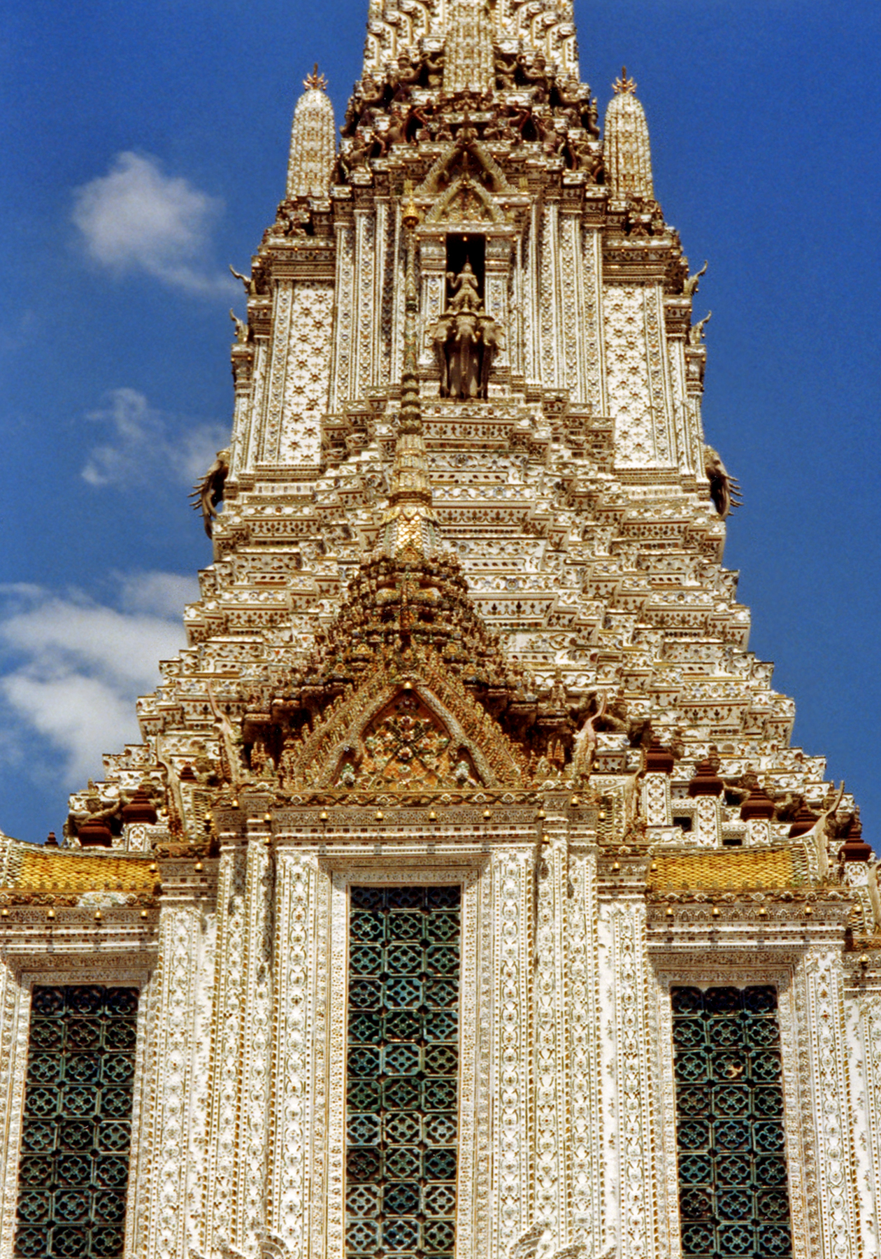
The brick core is covered with plaster and embedded with multi-colored porcelain shards from the ballast carried by Chinese trading ships.  The zig-zagging glistening surfaces impart a sense of rhythmic movement to the structure which follows a complex mandala plan.  The grouping of five towers represents Mount Meru, the central mountain of Buddhist cosmology, encircled by the guardians of the four directions.  

Wat Arun Plan RevSet in a prominent riverside location, Wat Arun is a distin-ctive beloved Bangkok land-mark.  Many of Bangkok’s most famous temples and historical monuments lie on the banks of the Chao Phraya River which winds through the city and the best way to visit them is by a long-tailed motor boat.  These water taxis offer a refreshing alternative to the modern city’s notoriously   congested   traffic.

Bangkok’s fascinating temples are a welcome respite from frenetic modernity; places of quiet meditation where history comes alive and  time  seems to  stand  still.

BK Wat Arun Side REV
View of Wat Arun

Magical Angkor

The renowned temple complex of Angkor Wat is only one of many impressive monuments spread across 200 sq. km. in northwestern Cambodia.  This region was home to several successive capitals of the Khmer empire over a period of 400 years from the 9th to the 13th centuries CE. Many buildings have collapsed or have been covered up by jungle so that today only forty accessible sites remain, known collectively as Angkor.   Although the sites have been cleared of vegetation and carefully restored, the humid exuberance of the tropical jungle is overpowering.   Some structures have been left purposely untouched still tangled in vines and tree roots fulfilling every traveler’s romantic notion of a mysterious lost world.

Angkor Moat Spires
Angkor Moat and Spires — (click photos to enlarge)

According to legend, an Indian nobleman conquered the land and married a local Naga princess (who was half-human and half-serpent).  The ancient tale mythologizes the union of these two cultures and attests to the importance of water in Khmer society.   In the 9th century Jayavarman II, who had been educated at the indianized Sailendra kingdom of Java, became ruler of the Khmers and introduced the cult of the devaraja (divine king) which identified the person of the king with the Hindu deities Shiva and Vishnu. The Indian concept of a sacred temple-mountain was also adopted so successfully that it would become synonymous with Khmer monumental architecture.

Angkor Overview LG
Overview of Angkor Wat

Angkor is located in a large basin bounded by the Tonle Sap lake to the south and mountain ranges to the north. The Mekong River and its tributaries traverse Cambodia, flowing from their source in the Himalayas to the South China Sea.   After the rainy season, silted channels cannot accommodate the excess water and the river backs up,  flooding the Tonle Sap and doubling its size.  The flooded area becomes an ideal habitat for fish and rice cultivation.  The rulers of Angkor achieved feats of hydraulic engineering to control and manage this water supply as their source of power and prosperity. Two large reservoirs, the East and West Barays, supplied the city’s water.   Like the verdant backdrop of vegetation that surrounds it, the reflective expanses of these vast water features greatly enhance Angkor’s aesthetic appeal.

Angkor Moat
The Moat Serves as Water Supply

In the flat landscape of the region several isolated hills stand out and their promontories became the site of the first temples.  By the 10th century, the basic design of a single tower atop a stepped platform was expanded into a five-tower design, where a large central tower symbolizing Mount Meru is surrounded by four smaller ones at each corner and stairs at the four cardinal directions in a cruciform plan. These basic elements multiplied throughout the monument form the radiating geometric pattern of a cosmic mandala diagram.   Unlike other monuments at Angkor and Hindu temples in general,  Angkor Wat faces West, the region of the dead,  not East and the rising sun. It may have been built as a funerary monument for Suryavarman II (1113 -1150 CE), one of the greatest Khmer rulers.

PLAN SKETCH Angkor Wat
Plan of Angkor Wat

Angkor Wat (wat means temple) is immense, bounded by three con-centric walled enclosures and surrounded by a wide moat.  The moat is crossed by a stone causeway leading to a tall gopura or entry tower (derived from South Indian temples).   Towers also rise at the corners of the enclosure walls and over each of the four entrances. The walls are not defensive in nature, but rather function as psychological barriers circumscribing a sacred space.  Steep stairs lead to the central summit of five towers whose tapering profiles resemble sprouting lotus buds.  Only the king and priests were allowed on the top level.  Thus at Angkor Wat  as one moves inward into the heart of the temple complex one simultaneously ascends, physically enacting the symbolism of climbing a sacred mountain.

ANGKOR door tower
Ascending the Temple Mountain

The central summit, home of the god-king, is ringed by long raised galleries with vaulted stone roofs and colonnades open on one side. The inner walls are covered with exquisite bas reliefs depicting the Hindu Ramayana epic, court processions and battle scenes.  The galleries also feature over 1,500 reliefs of apsaras  (celestial dancers of Hindu mythology) no two alike.  They stand in graceful poses, gorgeously attired and bejeweled, enchanting visitors with their timeless allure.  Walking down the deserted corridors and empty galleries, through slanting shafts of light and darkness,  one can almost hear their long-vanished whispers and lilting laughter emanating from the walls.

Angkor 2 Apsaras
Apsara Relief
Angkor Dancer
Dancer Resembles Ancient Counterparts

The nearby city of Angkor Thom was built by king Jayavarman VII (1181-1220) in an area slightly to the north of Angkor Wat.  The city was laid out in a quadrilateral ground plan and surrounded by an enclosure wall and moat.   A bridge leading to the city gates crosses the moat, ornamented on each side with a row of mythological figures holding the body of a giant serpent as the railing.   The entryway gopuras feature the distinctive colossal faces looking out toward the four directions.   At the very center of the city, Jayavarman VII placed his own temple-mountain, the Bayon, dedicated to the Buddha.  His monument evinces the interplay between Hinduism and Buddhism prevalent at that time.

Angkor Bayon towers
Faces on the Towers of the Bayon

Over 200 faces carved on 54 towers give the temple its surreal and enigmatic character.  They feature the famous “Smile of Angkor,” downcast eyes and serene expression considered the epitome of Khmer art.  They have been interpreted as representing the omni-presence of the king in the guise of his patron deity the Bodhisattva Lokeshvara.    Angkor Thom was designed as a microcosm of the universe,  a giant mandala divided into four quarters with concentric monuments radiating outward from the central temple-mountain of the Bayon, seat of the powerful god-king and cosmic link between heaven and earth.

Angkor Bayon Face
The Smile of Angkor

Art and Nature in Bali

The beautiful tropical island of Bali boasts a rich and complex culture belying its small size.   For centuries Bali was culturally and politically linked to neighboring Java, home to a powerful maritime empire influential throughout Southeast Asia.   After the spread of Islam to the Indonesian archipelago in the 16th century, the Hindu aristocracy of Java with its priests, scholars, artists, dancers and musicians fled to the secluded sanctuary of Bali, adding to the small island’s cultural heritage.  Today Bali is the last stronghold of Hinduism in Indonesia.   Balinese Hinduism is a fascinating mixture of adopted Indian philosophy and rituals overlaid upon the island’s indigenous animism with its ancestor worship and magical practices.  In Balinese cosmology spirits are everywhere, and their propitiation through daily offerings and rituals maintains the cosmic order and the balance between good and evil forces.   The famous Balinese dance dramas depict this mythic world of gods and nature spirits, with their flower bedecked and gorgeously costumed dancers gracefully gesturing to the hypnotic music of the gamelan.

Barong Dance
Balinese Dance Drama — (click photos to enlarge)
Gamelan
Gamelan Orchestra

The range of towering volcanoes at the center of the island is con-sidered to be the realm of the gods, with Gunung Agung, the highest mist shrouded peak being the home of Shiva.  Perched on its slopes is Pura Besakih,  Bali’s most sacred “Mother Temple” originally dating from the 14th century.   It consists of a series of courtyards connected by steep stairways, each containing multi-roofed thatched shrines resembling pagodas.  They are called “meru” harking to the Hindu mythical mountain at the center of the universe.   Temple courtyards also  function  as  performance  spaces  for  sacred  music  and  dance. They are entered through unusual split gateways with no top lintels and each side ending in a pointed wing-like projection.   As the place of transition between secular and sacred space, temple doorways  are decorated with protector masks and flanked by guardian figures.

Pura Besakih Climb
Climb to Pura Besakih
PuraBesakih Roofs
Merus at Pura Besakih

Balinese art is imbued with a baroque sensibility inspired by the exuberant tropical environment.   The cave of Goa Gajah dates from ca. 1,000 CE.   The side of a low hill has been carved with intertwined plants, animals and decorative scrolls which seem to move and writhe as they emerge from the dark depths of the earth,  bursting forth in astonishing profusion. They surround a giant stone face whose mouth forms the entrance to a small natural cave.  The face is said to represent Bhoma (born of the earth) the son of Vishnu,  ruler of the waters, and the earth goddess whose union ensures the fertility of the soil and brings forth vegetation.   Nearby is a ritual bathing pool fed by natural springs and decorated with statues of women holding pots from which the water pours into the pool.   Thus cave and pool symbolically represent the importance of water in Balinese life.

Goa Gajah Cave View
Cave of Goa Gajah
Goa Gajah Face Vert
Face Detail

The spectacular contoured rice terraces that blanket the hillsides of the central highlands depend on an elaborate irrigation system, one of the oldest in continuous use in the world.   Water from streams and mountain lakes has been diverted into aqueducts and channels that are maintained through communal work and rituals tied to the social and religious organization of the surrounding farming villages.

Terraces
Highland Terraces

The town of Ubud in the central highlands is the cultural heart of the island.   Away from the tourist traffic of the beach resorts,  it is still possible to experience the unique integration of nature and culture that is traditional Bali:  a verdant landscape animated by the spirits of forests, waters and mountains kept in ecological and spiritual balance by the power of rituals and the beauty of art.

Doorway in Ubud
Temple Doorway in Ubud

Borobodur: Ascending Toward Enlightenment

In the first centuries of the Common Era,  Indian traders began expanding their sphere of influence throughout Southeast Asia, establishing outposts that eventually flourished into independent indianized kingdoms.   Their trade routes also spread Indian culture and religious ideas in a syncretic mix of Hinduism and Buddhism (which still coexisted at that time) colored by mystical Tantric elements.  This Indo-Javanese period spans from the 7th to the 10th centuries CE,  when  the  Sailendra  dynasty  ruled  Java,  Sumatra  and the Malay Peninsula.

Boro Corner View
View of the Galleries — (click photos to enlarge)
Boro OVERVIEW
View of the Monument

The Sailendras were Buddhists, and their greatest achievement was the construction around the year 800 CE of Borobodur, the largest Buddhist monument  in the world.    This  unique  structure,  built atop a low natural hill in central Java, is a three-dimensional architectural mandala.  It is not a building in the normal sense of the word,  as it is completely open to the sky and has no interior spaces.  Its design incorporates the symbolism of Mount Meru (the sacred mountain at the center of Hindu and Buddhist cosmology), the geometric patterns of a mandala diagram (used to focus psycho-spiritual energies), and bell-shaped stupas (Buddhist monuments housing holy relics).

Boro PLAN
Plan of Borobodur

The scale of Borobodur is impressive: the monument rises up nine levels as a series of receding terraces that form a truncated pyramid. The base platform, shaped as a square with indented corners, measures 370 ft. on each side.  It is surmounted by five square terraces and three circular ones, linked by four stairways that rise to the summit, which is topped by a large bell-shaped stupa.

Boro Ascent 3
Ascent to the Summit

Pilgrims traditionally ascend the eastern stairway to begin their clockwise circumambulation of the monument; a complete circuit of the four square terraces covers a distance of 3/4 of a mile.  The square terraces are surrounded by balustrades that create partially enclosed galleries which are open to the sky.  The galleries are decorated with over 500 life-sized Buddha images and some 8,202 linear ft. of exquisitely carved relief panels.

Boro Market Relief
Scenes of Daily Life

The entire sculptural program is conceived in didactic progression.  Reliefs on the base level offer lively depictions of contemporary life that illustrate the workings of karma, the spiritual law of cause and effect,  in human affairs.   Most of these carvings were later covered up by the wide platform built in order to stabilize the structure.  The relief carvings on the first terrace feature scenes from the life of the historical Buddha and fantastic tales of his earlier incarnations called Jatakas.  These panels contain some of the most famous images from Borobodur. The next four terraces depict the education of Sudhana a young man who serves as a model for the spiritual seeker of Buddhism.  The imagery of the upper galleries becomes progressively more esoteric as it focuses on the bodhisattvas, transcendent saintly figures of the Mahayana pantheon and their philosophical teachings.

Boro Buddha Relief
Scenes of Buddha’s Life
Boro Buddha Image
One of 500 Buddha Statues

In the upper circular terraces we pass from the world of forms into formlessness; from the wealth of figurative detail which decorates the lower terraces into pure abstraction.  Seventy-two hollow stupas are arranged in three concentric circles, each one pierced by small diamond or square shaped openings that allow only partial glimpses of the Buddha images inside, all seated in the pose of preaching the first sermon, called “Setting in Motion the Wheel of the Law.”

Boro Ascent 2 SCAN
Buddhas and Stupas of the Upper Levels

The enclosed galleries of the lower terraces obscure the view so a person cannot see very far beyond their immediate surroundings; forcing  one,  as  it were,  to  focus  on  the  teachings  being  presented at whichever stage of the journey one is at.   But once the topmost circular terraces are reached,  suddenly  the  space  opens up offering a magnificent 360-degree view of the light-filled surrounding plain.  This exhilarating experience vividly illustrates a spiritual seeker’s progression from the darkness and limitations of ignorance to the clarity and boundless freedom of enlightenment.

Boro Ascent 1 SCAN
View From the Top

Borobodur is a three-dimensional interactive exposition of Buddhist doctrine, capable of transforming consciousness through its very design. The pilgrim gradually ascends the sacred mountain while circumambulating in spiral fashion each level of the mandala, undergoing in the process a symbolic transformation;  leading from the depths of ignorance, upward through successive stages of increasing self-awareness and knowledge of the dharma,  to the final achievement  of  the  heights  of  spiritual  transcendence  in  nirvana.

Boro Buddha Back 2
Watching Over the Landscape